We are thrilled to release the final report for ART Bay Area!
The ART Bay Area report is the first ever regional comparison of the impacts of sea level rise on people, the environment, and the regional systems we rely on. This report provides a better understanding of where we are vulnerable and lays out a pathway to plan for the future.
ART Bay Area “Short Report”
In addition to the full report available for download below, the ART Bay Area Short Report: Summary of Regional Sea Level Rise Vulnerability and Adaptation Study is available for download. The “Short Report” provides a high-level overview of the full ART Bay Area report and snapshots of consequences from flooding to the four regional systems assessed.
Adapting to Rising Tides Bay Area Main Report
ART Bay Area Main Report
The ART Bay Area report is available for download in various sections: ART Bay Area Main Report contains the Executive Summary, Introduction, Regional Systems Overview, Local Assessments Introduction, Regional Adaptation Responses and Looking Forward chapters.
Chapter 2.0 Regional Systems Assessments contains in-depth sections on each of the four regional systems. These sections are available for separate download, including Chapter 2.5 Transportation Networks, 2.6 Vulnerable Communities, 2.7 Future Growth Areas, and 2.8 Natural Lands.
As part of the study, ART Bay Area evaluated thirty-two Focus Areas organized geographically around the region in thirteen Local Assessments, which can be downloaded in the links below. Click the images and links to download individual report sections.
Regional Chapter Sections: Transportation, Vulnerable Communities, Future Growth Areas and Natural Lands
Chapter 2.5 Transportation Networks
Chapter 2.6 Vulnerable Communities
Chapter 2.7 Future Growth Areas
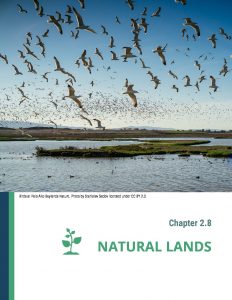
Chapter 2.8 Natural Lands
Local Assessment Sections: Case Studies of Shared Vulnerabilities from Flooding
Local Assessments available for individual download:
- A. Richardson
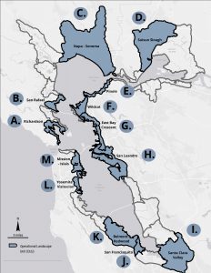
- B. San Rafael
- C. Napa-Sonoma
- D. Suisun Slough
- E. Pinole
- F. Wildcat
- G. East Bay Crescent
- H. San Leandro
- I. Santa Clara Valley
- J. San Francisquito
- K. Belmont-Redwood
- L. Yosemite-Visitacion
- M. Mission-Islais

The ART Bay Area Main Report includes an Adaptation Chapter with selected adaptation responses identified as “easy-wins.” For a full list, please see the Adaptation Responses spreadsheet.
The Appendix includes additional information on methodologies used in ART Bay Area analyses.
Sea level rise is just one of many factors that will influence how we live, work, and engage with our environment and communities in the Bay Area in coming decades – but the urgency is clear and the cost of inaction is too high.
ART Bay Area helps move the region forward in making proactive decisions about how best to manage sea level rise to ensure that our future is safe and resilient. You can read the official press release here.
What is the ART Bay Area Report?
The Metropolitan Transportation Commission (MTC) partnered with the Bay Conservation and Development Commission’s Adapting to Rising Tides (ART) Program and the Bay Area Regional Collaborative (BARC) to write a proposal for a Caltrans Sustainable Transportation Planning Grant and was awarded $800,000 to develop a regional adaptation planning process aimed at increasing the resilience of the region’s transportation and community assets. The Bay Area Toll Authority (BATA) is contributing $400,000 in matching funds, resulting in a $1.2 million grant for this work, which will be conducted over the next two and a half years, from the spring of 2017 to the winter of 2019.![]()
Assets included in the study
• Interstates and highways, passenger and cargo rail, BART, Bay Trail, transit service
• Priority Development Areas
• Priority Conservation Areas
• Community members with characteristics that may make them more vulnerable to flooding
The San Francisco Bay Area is the fourth largest metropolitan area in the country, with a current population of 7.4 million people. The region, made up of nine counties (Alameda, Contra Costa, Marin, Napa, San Francisco, San Mateo, Santa Clara, Solano, and Sonoma), is diverse in every way – from its people to its economy to its environment. A significant proportion of the region’s communities, job centers and transportation infrastructure, among other critical assets, are located along the San Francisco Bay shoreline with some locations at the risk of flooding today and others at risk of future flooding due to the changing climate.
While the region has been dealing with the current challenge of upgrading and seismically retrofitting aging infrastructure, we recognize that these systems were not designed to be resilient to changes to precipitation, temperature, and  increasing flooding due to sea level rise. Given that the Bay Area’s expansive and growing transportation network and development patterns are critical to the health, mobility and longer-term prosperity of Bay Area communities, it is essential the region clearly understands our vulnerabilities to flooding and sea level rise so that we can implement the strategies necessary to make our communities and transportation infrastructure more resilient now and into the future.
The project will increase the resilience of the Bay Area’s transportation system to current and future flooding, while also improving the safety and sustainability of our communities, particularly our most vulnerable and disadvantaged communities. To address this challenge, the project will conduct a regional vulnerability assessment of the Bay Area’s transportation infrastructure, Priority Development Areas (PDAs) and Priority Conservation Areas (PCAs) as identified in the Sustainable Communities Strategy (Plan Bay Area), and vulnerable and disadvantaged communities. The project will also develop a suite of adaptation strategies to improve the resilience of Bay Area transportation assets and communities for inclusion in Plan Bay Area as well as other appropriate local and regional planning documents.
Asset Category Contacts:
| Priority Development Areas: Jaclyn Mandoske (415)352-3631 |
Priority Conservation Areas: Nicolas Sander (415)352-3625 |
Transportation: Todd Hallenbeck (415)352-3667 |
Vulnerable Communities: Dana Brechwald (415)352-3656 |
ART Bay Area Regional Working Group Meeting Materials
Related Resources
CalTrans Grant Summary![]()
Bay Area Regional Collaborative – Raising the Bar on Regional Resilience Report![]()
ART Transportation Resilience Project
Capital Corridor Passenger Rail Vulnerability Assessment
Oakland Alameda Resilience Study
Stronger Housing, Safer Communities Project
Caltrans Sustainable Transportation Planning Grant Program
If you are interested in being part of the Regional Working Group Please:

For More Information:
- Dana Brechwald
- Dana.Brechwald@bcdc.ca.gov
- 415-352-3656