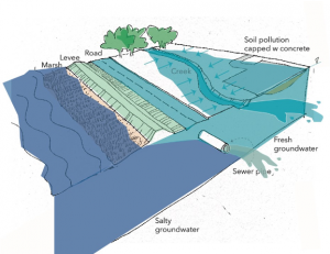
 Coastal communities throughout California are actively planning for coastal impacts from climate change.Many impacts, such as sea level rise, storm surges, shoreline change and bluff erosion, have a comprehensive suite of scientific information that can help communities plan. Accordingly, many communities have completed vulnerability assessments and have begun identifying adaptation strategies to plan for this overland flooding. However, emerging research indicates that sea level rise, in addition to its potential to increase overland flooding, can also lead to rising shallow groundwater tables and lead to flooding hazards where we might not expect them. This information gap was identified in the ART Bay Area project as a critical limitation to our understanding of shoreline flood risk and effective adaptation planning.
In recognition of the growing body of scientific study and interest by coastal communities, the County of San Mateo (SMC), the US Geological Survey (USGS), Silvestrum, and the SF Bay Conservation and Development Commission (BCDC) convened a workshop on November 13, 2019 in Oakland, CA, to discuss the importance of considering the influence of sea level rise on the shallow groundwater table, and how some Bay Area stakeholders are planning for and adapting to this threat.
Links:

For more information:
- Todd Hallenbeck
- Todd.Hallenbeck@bcdc.ca.gov
- 415-352-3667