ART Bay Area Sea Level Rise and Shoreline Analysis maps are now available online at the Bay Shoreline Flood Explorer.
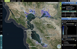
The ART Bay Shoreline Flood Explorer allows for interactive exploration and download of the Bay Area sea level rise and shoreline analysis maps. These maps depict areas at risk of temporary or permanent flooding due to sea level rise and storms as well as shoreline overtopping.
The ART Bay Shoreline Flood Explorer is a website designed to help Bay Area communities, local governments, and the general public understand current and future flooding risks due to sea level rise and storms. The website will help users learn flood concepts, explore interactive flood maps, and download GIS data. These maps show what could be at risk without adaptation and identify specific areas that face the greatest risk, helping Bay communities, governments, and businesses to drive strategic action.
The Bay Area Sea Level Rise and Shoreline Analysis maps are robust and accurate mapping products that leverage the latest LiDAR topographic data sets, the FEMA San Francisco Bay Area Coastal Study and San Francisco Tidal Datums Study, and the regional shoreline delineation developed by the San Francisco Estuary Institute.
Regional products include:
- County specific sea level rise and extreme tide matricesthat depict locally-relevant water levels and illustrate the “One Map, Many Futures” concept.
- Inundation mapping for ten scenarios that capture over 90 combinations of future sea levels and extreme tide conditions.
- Overtopping potential maps for all ten scenarios that depict where the Bay may overtop the shoreline. Coupled with the inundation maps, the overtopping potential maps help in identifying the shoreline locations and flowpaths that could lead to inland flooding.
- Maps and data downloads available
Project Status
Mapping and analysis is now complete for all nine Bay Area counties and including updates to the previously completed county mapping and analysis to ensure seamless, unified regional mapping and analysis products.
You can learn about, explore, and download the maps online at the Bay Shoreline Flood Explorer
The final project report provides a summary of the sea level rise mapping scenarios, inundation mapping methods, stakeholder review process, and key findings for each county. Key findings by county include a high-level overview of key vulnerabilities, especially in the near term, that may benefit from further examination. Each county section also presents a high-level discussion of SLR impacts to bridge approaches that may be of interest to the Bay Area Toll Authority to inform the selection of focus areas for future studies. Access the report here: BATA ART SLR Analysis and Mapping Report.
Related Materials
Dumbarton Bridge Touchdown Study
BATA ART SLR Analysis and Mapping Report
Sea Level Rise & Overtopping Analysis for San Mateo County’s Bayshore
San Francisco Sea Level Rise Mapping
Extreme Storms in San Francisco Bay – Past to Present
Related Projects
Adapting to Rising Tides Alameda County Project
Adapting to Rising Tides Contra Costa Project
San Mateo County Inundation Scenarios Map Viewer
SFEI’s Flood Protection Infrastructure Mapping
Project Partners
The San Francisco Bay Conservation and Development Commission’s Adapting to Rising Tides Program have partnered on this effort with AECOM’s Coastal Engineering team led by Kris May, the Metropolitan Transportation Commission, the State Coastal Conservancy, the San Francisco Estuary Partnership, the San Francisco Estuary Institute, Alameda County Flood Control and Water Conservation District and the San Francisco Public Utilities Commission. Funding for the development of the ART Bay Area Flood Explorer website comes from California’s Greenhouse Gas Reduction Fund, the National Oceanic and Atmospheric Administration, the Metropolitan Transportation Commission (MTC), and BCDC. Website development was supported by the San Francisco Estuary Institute.

For more information:
- Todd Hallenbeck
- Todd.Hallenbeck@bcdc.ca.gov
- 415-352-3667